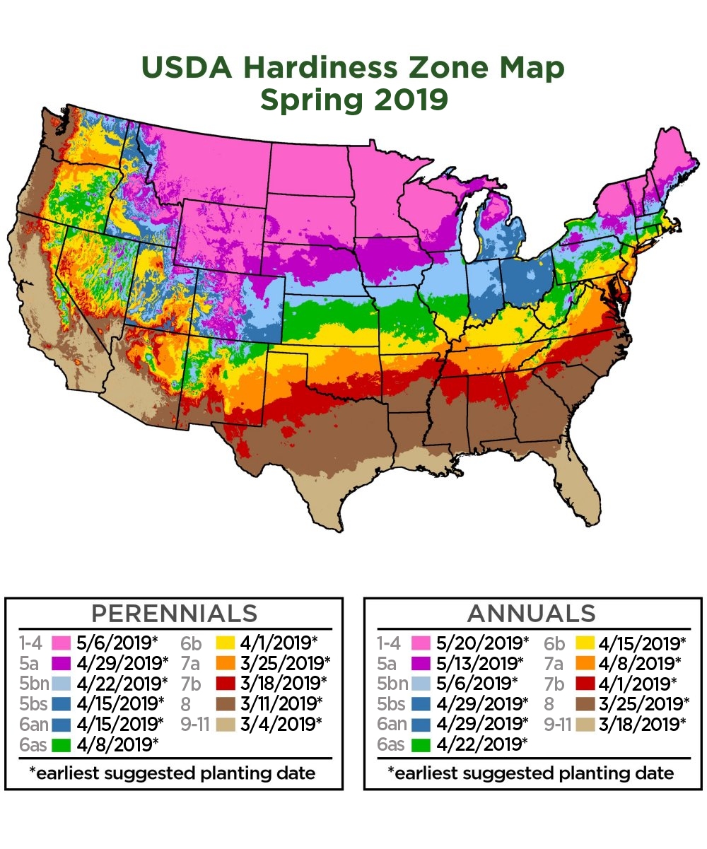

The U.S. Department of Agriculture designed a map of the United States that shows color-coded plant hardiness zones as a guide for where plants may survive across the country. It is divided into 10° F increments. Each zone is based on an average annual extreme minimum temperature observed over a 30-year period, not the lowest temperature an area has ever reached. The zones are labeled from 1 to 13, with zone 1 being the coldest.
The Plant Hardiness Zone Map (PHZM) is an excellent guide for gardeners to discover which plants are likely to survive in their area. Plant breeders and professional growers use hardiness zones to communicate to gardeners where the plants they have bred and developed can be grown successfully.
Two new zones were added to the USDA PHZM in 2012. Zones 12 and 13 cover Hawaii and Puerto Rico, with average annual extreme temperatures above 50°F and 60°F respectively. This new information can be quite helpful for gardeners around the country who grow tropical plants indoors.
The 2012 PHZM used today is based on data collected from 1976 – 2005. The previous 1990 PHZM was created from data collected from 1974 – 1986. Comparing the two maps, you will notice that zone boundaries in some areas have shifted slightly. This is a result of more sophisticated mapping techniques and an increase in weather station observation data. If your zone identification shifted on the latest PHZM version, there is no reason for concern. Plants growing successfully in your area will continue to do so.
Although the 2012 PHZM was compiled using the most sophisticated measures to date, there are still microclimates not shown on the map. Too small in scale to be included on the map, microclimates are small pockets of temperatures that vary from the surrounding area’s temperature. Plants can often survive outside their listed hardiness zones in microclimates. Warmer microclimates can be caused by large areas of blacktop or concrete while cooler microclimates can result from hills, valleys and open spaces. Gardeners may experience microclimates caused by low spots, retaining walls or other sheltered areas in their own landscape.
The Plant Hardiness Zone Map is a great place to start when choosing plants for your garden or landscape. However, keep in mind that other factors can contribute to their survival as well. Wind, rainfall, snowfall, humidity, light exposure and soil type all play a role in a plant’s success. Both new and experienced gardeners may find it a fun challenge to grow and care for plants outside their hardiness zones. Many gardeners already do so by growing tender or tropical plants that require extra care to survive a winter season in areas with low temperatures and snow.
|
| Categories |
|
+ Behind The Scenes
+ Cacti & Succulents
+ Container Gardening
+ Do-It-Yourself Projects
+ Drought Tolerant Plants
+ Edible Gardening
|
+ Frequently Asked Questions
+ Garden Planning And Design
+ Gardening Care & Maintenance
+ Gardening In Your Zone
+ Glossary Of Gardening Terms
+ Growing Minds - Gardening With Kids
|
+ Houseplants
+ How To Articles
+ Limited Space Solutions
+ Low Maintenance Gardening
+ Pests And Pollinators
+ Recipes
|
+ Seasonal Gardening
+ Videos
+ Year Round Beauty/Evergreens
|
|
+ Behind The Scenes
+ Cacti & Succulents
+ Container Gardening
+ Do-It-Yourself Projects
+ Drought Tolerant Plants
+ Edible Gardening
+ Frequently Asked Questions
+ Garden Planning And Design
+ Gardening Care & Maintenance
+ Gardening In Your Zone
+ Glossary Of Gardening Terms
|
+ Growing Minds - Gardening With Kids
+ Houseplants
+ How To Articles
+ Limited Space Solutions
+ Low Maintenance Gardening
+ Pests And Pollinators
+ Recipes
+ Seasonal Gardening
+ Videos
+ Year Round Beauty/Evergreens
|
|
+ Behind The Scenes
+ Cacti & Succulents
+ Container Gardening
+ Do-It-Yourself Projects
+ Drought Tolerant Plants
+ Edible Gardening
+ Frequently Asked Questions
+ Garden Planning And Design
|
+ Gardening Care & Maintenance
+ Gardening In Your Zone
+ Glossary Of Gardening Terms
+ Growing Minds - Gardening With Kids
+ Houseplants
+ How To Articles
+ Limited Space Solutions
+ Low Maintenance Gardening
|
+ Pests And Pollinators
+ Recipes
+ Seasonal Gardening
+ Videos
+ Year Round Beauty/Evergreens
|
| Categories |
|
+ Behind The Scenes
+ Cacti & Succulents
+ Container Gardening
+ Do-It-Yourself Projects
+ Drought Tolerant Plants
+ Edible Gardening
+ Frequently Asked Questions
+ Garden Planning And Design
|
+ Gardening Care & Maintenance
+ Gardening In Your Zone
+ Glossary Of Gardening Terms
+ Growing Minds - Gardening With Kids
+ Houseplants
+ How To Articles
+ Limited Space Solutions
+ Low Maintenance Gardening
|
+ Pests And Pollinators
+ Recipes
+ Seasonal Gardening
+ Videos
+ Year Round Beauty/Evergreens
|
|
|
|
|
|
|
|
|||
|
|||
|
|||
|
|||
|
|||
|
|||
|
|||
|
|||
|
|||
|
|||
|
|||
|
|||
|
|||
|
|||
|
|||
|
|||
|
|||
|
|||
|
|||
|
|||
|
|||
|
|||
|
|||
|
|||
|
|||
|
|||
|
|||


